LAOS
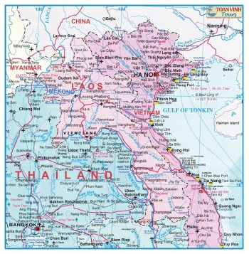
 The People's Democratic Republic of Laos is located in the centre of Indochina, sharing borders with China to the north, Myanmar to the northwest, Thailand to the west, Cambodia to the south, and Vietnam to the east.
With an area of 236,800 square kilometres. Around 70% of its terrain is mountainous, reaching a maximum elevation of 2,820 m in Xieng Khouang province. The landscapes of northern Laos and the regions adjacent to Vietnam in particular are dominated by hills.
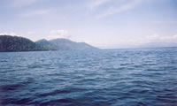
The Mekong river is the main geographical feature in the west and, forms a natural border with Thailand in some areas. The Mekong flows through nearly 1,900 km of Laos territory and shapes much of the lifestyle of the people of Laos. In the south the Mekong reaches a breadth of 14 km, creating an area with thousands of islands.
Time:
Time in Laos is 7 hours ahead of Greenwich Mean Time (GMT* 7).
Climate:
Laos enjoys a tropical climate with two distinct seasons – the rainy season from the beginning of May to the end of September and the dry season from October through to April. The yearly average temperature is about 28°C, rising to a maximum of 38°C in April and May. In Vientiane minimum temperatures of 19°C are to be expected in January. In mountainous areas, however, temperatures drop to 14-15°C during the winter months, and in cold nights easily reach the freezing point.
The average precipitation is highest in southern Laos, where the Annamite mountains receive over 3000mm annually. In Vientiane rainfall is about 1500-2000mm, and in the northern provinces only 1000-1500mm.
Flora and Fauna :
 Loas has one of the most pristine Ecologies in South East Asia. An estimated half of its woodlands consist of primary forest, in particular the tropical rain forest. Unlike the vegetation in the bored climate of northern Europe and the United States, tropical rain forest is composed of three vegetative layers. The top layer is dominated by single-trunked, high-reaching trees, so-called dipterocarps. The middle canopy consists of hardwood such as teak. Beneath, small trees, grasses, and sometimes bamboo can be found.
In addition to a fascinating vegetation, Laos plays host to a diverse animal kingdom. Several exotic mammals are endemic such as leopard cats, Javan mongoose, goat-antelopes, rare species of gibbons and langurs, Malayan sun bear, Asiatic black bear, gaur and others. The discovery of the Saola Ox, a breed of deer-antelope, in Vietnam a few years ago caused a sensation. This extremely rare animal inhabits the eastern border regions of Laos, too. And these remote areas probably still hide other unknown species.
In the south of Laos, near Khong Island, Irrawaddy dolphins inhabit the Mekong river. While many species of wildlife are shy and can rarely be seen, spectators will generally be able to spot the dolphins in spring when the water level of the Mekong is lowest. Laos is also rich in resident and migrating birds. One of the more notable ones is the rare Green Peafowl.
Language:
Lao language is the national language. Others languages used are French, English, Chinese, Thai and Vietnamese.
Religion:
 Buddhism first appeared in Laos during the eighth century A.D as shown by both the Buddha image and the stone inscription found at Ban Talat near Vientiane, now exhibited at the Museum of Ho Prakeo. After the foundation of the unified Kingdom of Lane Xang, King FaNgum (14th century) declared Buddhism as the state religion and urged the people to abandon animism or other beliefs such as the cult of spirits. His policy meant to develop the Lao culture based on a common faith: the Theravada Buddhism is the professes religion of about 90% of Lao people. Buddhism is an inherent feature of daily life and casts a strong influence on Lao society. Lao woman can be seen each morning giving alms to monk for at least a short time in their lives.
Traditionally they spent three months during the rainy season in a Vat - a Buddhist temple. But nowadays most men curtail their stay to one or two wee
 Stone tools discovered in Huaphan and Luang prabang provinces attest the presence of prehistoric man in its stage of hunters and gatherers over the Lao territory since at least 40,000 years ago. Agriculturist society seemed to appear during the 4th millennia BC as evidences have been found by archeologists- jar burials and other kinds of sepulchres have revealed a complex society in which Bronze objects appeared around 1500 BC and iron tools were known since 700 BC. The proto historic period is characterized by contacts with Chinese and Indian civilisations. As a result between the fourth and eighth century.
Between the fourth and eighth century communities along the Mekong river began to form into townships, so-called muang. This development culminated in the formation of the Lane Xang (million elephants) kingdom in 1353 by King FaNgum and established Xieng Thong now know as Luang Prabang to capital of Lane Xang Kingdom.
The kingdom was further expanded by his successors, one of the most notable being King Setthathirat who ruled from 1548-1571. He moved the capital to Vientiane and built That Luang Stupa, a venerated religious 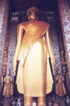 shrine and a temple to house the Phra Keo, the Emerald Buddha.
In the seventeenth century, under the reign of King Souliyavongsa, the Lane Xang kingdom entered its most illustrious era. The country established first contacts with Europeans. In 1641, a Dutch merchant of the East India company, Geritt Van Wuysthoff, and later, the Italian missionaries Leria de Marini visited the Kingdom of Lane Xang and described Vientiane as the most magnificent city of Southeast Asia.
After this golden age a palatial intrigue followed by fightings for the throne led ton the break-up of Lane Xang into the three kingdoms of Vientiane, Luang Prabang and Champassack which weakened all of them and created opportunities for new foreign aggressors to invade.
The Unsuccessful challenge of the Siamese by King Anouyong resulted in the virtual destruction of Lao was put under the French administration in1893. To recover its full rights and its sovereignity the Lao people started fighting against the French regime.
Under the leadership of the communist Party of Indochina ( founded in 1930). The struggle for the self determination and independence gained in importance and finally the International conference and the Geneva Agreement on Indochina in 1954 recognizing the independence of Laos, Vietnam & Cambodia culminated this long period of military and political upheaval.
The situation worsened during the Vietnam war although the Geneva Accord of 1962 had recognised the neutrality of Lao and forbade the presence of all foreign military personnel. By bombing the portion of the Ho Chi Minh trail crossing Laos, US forces dropped more bombs on Laos than they did world-wide during World War II.
On a per capita basis Laos is hence the most heavily bombed nation in history. Especially in Huaphan and Xieng Khouang provinces, where international teams are still clearing the terrain of unexplored ordinance, people still suffer from the legacy of the war.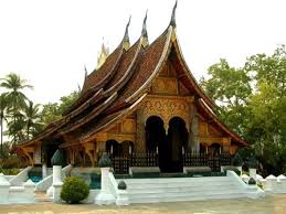
In 1975 under the leadership of Laos People's Revolutionary, victory after victory was scored until finally Laos People gained power in a bloodless take-over, establishing the People's Democratic Republic on December 2. It was the culmination of a successful for national liberation, and reinstatement of total independence. At present the multi ethnic Lao people are making efforts to defend and develop Laos in Line with the new policy of the party and government in order to lead the country to progress and prosperity.
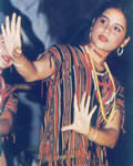
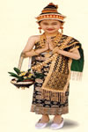
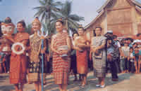
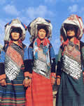
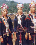
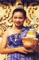 Laos has a total population of 4.6 million, 13% of whom live in Vientiane province. People share a rich ethnic diversity, comprising such groups as Hmong, Khmu, Yao, A'kha, Ikoh, Lu etc. Most of them have kept their own customs, dialects and traditional dress. In total 47 different groups are accounted for in Laos. These can be classified into three broad groups:
-
The Lao Lum (lowlanders) who make up 70% of the population and predominantly live along the Mekong river.
-
The Lao Theung (uplanders) who comprise 20% the population and live on the lopes and hills with an elevation of less than 1,000 metres.
-
The Lao Soung (hill tribes) who constitute 10% of the population and live in the mountainous areas.
The population density of Laos amounts to 19 people per square kilometre, a small number compared to the country's neighbours: 120 people per square kilometre in Thailand; and 200 people per square kilometre in China.
|
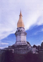
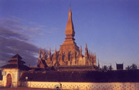
Lao people boast a plethora of distinctive monuments and architectural styles. One of the most notable structures is Thai Luang, the Great Sacred Stupa, in Vientiane. Its dome like stupa and four-cornered superstructure is the model for similar monuments throughout Laos. Stupas serve to commemorate the life of the Buddha and many stupas are said to house sacred relics (parts of Buddha's body).
Religious influences are also pervasive in classical lao literature, especially in the Pha Lak Pha Lam, the Lao version of India's epic Ramayana. Projects are underway to preserve classic Lao religious scripts which were transcribed into palm leaf manuscripts hundreds of years ago and stored in vats.
Another excellent example for the richness of lao culture is its folk music, which is extremely popular with the people throughout the whole country. The principal instrument is the khaen, a wind instrument which comprise a double row of bamboo-like reeds fitted into a hardwood soundbox. The khaen is often accompanied by a bowed string instrument or saw. The national folk dance is the lamvong, a circle dance in which people dance circles around each other so that ultimately there are three circles: a circle danced by the individual, another one by the couple, and a third one danced by the whole party. |
Lao people are frank, open and friendly, and they possess a strongly developed sense of courtesy and respect. Everyone who adheres to the latter will receive a warm welcome.
The generally accepted form of greeting among Lao people is the nop. It is performed by placing one's palm together in a position of praying at chest level, but not touching the body. The higher the hands, the greater the sign of respect. Nonetheless, the hands should not be held above the level of the nose. The nop is accompanied by a slight bow to show respect to persons of higher status and age. It is also used as an expression of thanks, regret or saying good-bye. But with western people it is acceptable to shake hands.
 When entering a vat or a private home it is customary to remove one's shoes. In Lao homes raised off the ground, the shoes are left at the stairs. In traditional homes one sits on low seats or cushions on the floor. Men usually sit with their legs crossed or folded to one side, women prefer solely the latter. Upon entering guests may be served fruit or tea. These gestures of hospitality should not be refused.
Since the head is considered the most sacred part of the body and the soles of the feet the least, one should not touch a person's head nor use one's foot to point at a person or any object. Moreover men and women rarely show affection in public. It is also forbidden for a woman to touch a Buddhist monk.
Passports:
All visitors entering Laos must possess valid passports.
Visas:
Visitors travelling to Laos for the purpose of tourism need a visa, which can be obtained in different ways. An easy way is to book a tour to Laos with an authorised travel agency abroad who has formal contact with one of local tour operators. This agency will provide you with the necessary form, enabling you to apply for the visa at your nearest Lao embassy or consulate (a list of these is provided at the back of this brochure) or you can make contact directly with local tour operators.
If you book a tour to Laos and you are resident of a country that does not have a Laos embassy or in case of urgency, you can obtain the visa upon arrival only at Vattay airport and Mittaphab bridge which both are the International border checkpoint in Vientiane. To do so you will need to meet at least some of the following conditions:
-
Pay a fee
-
Have a return air ticket or a valid visa from a third country.
-
Have a confirmation of hotel in Laos PDR.
-
Certificate of a bank statement or a life insurance.
The Kip is the official currency of Laos. The bank notes are presently in denominations of 20, 50, 10, 500 and 1,000 Kip.
All major currencies such as the US dollar, French franc, DM, Yen, Bath and others can be exchanged at blanks that are offered by numerous authorised private exchange bureaux. One exchange facility is available at Wattay Airport in Vientiane.
Exchange bureaux and banks will cash traveller cheques in major currencies. Furthermore, most domestic and foreign banks in Vientiane allow cash withdrawals on Visa credit card or Master card. In Vientiane, credit cards can be used in many restaurants and hotels, too. In case of journeys to remote areas it is, of course, advisable to take a good supply of Kip with you.
|
Travel by Air:
The latest information about flight schedules and routes is available at the Lao Aviation Head Office in 2 Pangkham Road, Vientiane, Tel: xxx856-21-212056, Fax: xxx856-21-212056.
Travel by Road: Laos has 18.153 km of national roads, 2.500 km of which are paved. The most important road is route No.13 linking which runs north-south from China to Cambodia. It links Pak Mong in the north with Khong in the south passing through major urban areas of Luang Prabang, Vientiane, Savannakhet, Champassack. Accept that, there are the road No.1 linked between Thailand and China, No.8 and No.9 linked between Thailand and Vietnam.
Travel by Boat: The Mekong river flows through 1,865 km of Laos. Although not navigable in its entirety, it provides a natural means of transportation over long stretches. In addition many tributary rivers of the Mekong river such as the Nam Ou, Nam Ngum, Se Don, an others. Rivers are used for water transportation. |
Eco-tourism:
Tropical forests, home to many rare species of flora and fauna are found in comparative abundance throughout Laos. As a consequence, Laos offers great attractions to a growing number of eco-tourists. By establishing necessary facilities, Laos intends to position itself as a unique travel destination. It want to avoid the negative impact on its environment which are a feature of traditional forms of tourism. In particular, Laos intends to preserve its typical culture and nature habitats. These measures shall help avert the imminent threats to nature in Laos such as shifting cultivation, chassng of rare animals, and widespread logging of primary forest.
A model for a resort operated in an ecologically friendly way is Tat Lo. Located in Saravane province on the banks of the Se Set river, it is constructed almost entirely from native materials using local techniques. Trekking and river rafting can be arranged in the area. Other regions such as Dong Hua Sao area in Champassack province are currently being surveyed with regard to their suitability for eco-tourism.
|
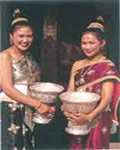
Laos is a mysterious and beautiful place inhabited by 47 ethnic groups. Each group has formulated its peculiar costumes based the diversified historical background, geographic situations and life style. These groups display a galaxy of over hundreds sorts of beautiful costumes and adornments, either hand-woven or embroidered.
|
Official Holidays:
In Laos, working days are from Monday to Saturday, from 8am to 12am and from 2pm till 5pm. Official Holidays includes:
International New Year January 1
Lao New Year mid April
International Labour Day May 1
Lao National Day December 2
Lao National Day is an official public holiday during which parades and speeches commemorate the 1975 Lao People’s Revolutionary Victory over monarchy.
Avariety of festivals and religious ceremonies are observed throughout the whole year. The most important ones are listed below.
Mid January:
Boun Khoun Khao: Harvest festival in villages. A ceremony is performed giving thanks to the spirit of the land.
February:
Vat Phou festival: On the full moon of the third lunar month (usually in early February), the residence of Champassack celebrate the traditional Vat Phou festival. The festivities include elephant races, water buffalo fighting, cock fighting and many traditional performances.
Boun Khao Chi: a ceremony held at the vat in the morning, when a special "bread made of sticky rice" is offered.
Lunar New Year: is celebrated by the Chinese and Vietnamese communities in Laos. Firecrackers explode throughout this holiday and mouth-watering cakes and sweetmeats are made especially for the occasion.
March:
Boun Pha Vet: commemorates King Vessanthara's reincarnation as the Buddha. Fortune-telling is a highlight of this three days festival.
April:
Boun Pimai: the Laos New Year, is celebrated in mid April. On the first day of festival, Buddha images are taken out of the temples to be cleaned with scented water. The water which drops from the Buddha images is collected and taken home in order to pour it on friends and relatives as an act of cleaning and purification. On the evening of the final day, the Buddha images are returned to their proper shrines. In Luang Prabang the festival also features a beauty contest with the crowning of Miss Pimai.
Mid May:
Boun Visahhabousa: celebrates the day of Buddha's birth, enlightenment and passing away. It is a time to pay one's respects to ancestors with chanting, sermons, and a candlelit procession at night.
Boun Bangfai: the rocket festival, is held at the beginning of the rainy season. The festival is a call for rain and a celebration of fertility. In the morning a religious ceremony is performed. In the afternoon, people gather in the fields on the outskirts of village and towns to launch self-made firework rocket. Different communities compete for the best decorated and the highest travelling rocket. Men disguised as women perform vaudeville acts using wooden phalli in order to anger the gods. As revenge, the gods are expected to send thunderstorms. Beginning around the middle of May, the rocket festival are staggered from place to enable greater participation and attendance.
June:
This is time when an offering to the spirits can be made in a corner of one's garder, very early in the morning.
July:
Boun Khao Phansa: the beginning of the Buddhist lent. For a break-taking sight, visit one of the large temples at dawn to see hundreds of worshippers, mostly women wearing vividly coloured silks, performing the rituals of Tak Baat, offering gifts to the monks, and Yaat Nam, poring water into the ground to ensure that the offerings benefit one's ancestors. During the next three-month period, monks spend most of their time in prayer and meditation and are restricted from spending nights in other vats other than their own.
August:
Boun Kao Padabdinh: the observation of a practice of making offerings to the dead.
September:
Boun Khao Salak: is for offerings to be made for the dead, to share merit with them.
October:
Boun Ok Phansa: that marks the end of the monks' three-month-fast and retreat during the rainy season. At dawn, donations and offerings are made at the temples. Prayers are chanted by the monks, and at dusk candlelight processions wind round the temples. Concurrently, hundreds of decorated candlelit-floats, made of paper, are set a drift in the rivers. These carry offerings and incense, transforming the rivers into a fragrant snake of sparkling. This ceremonial part is called Boun Lay Heua fai. The biggest event of the Ok Phansa festival, Boun Souang Heua, is the boat race festival, is held the day after Ok Phansa. Crowds gather at the Mekong river to watch 45 members teams rowing wooden pirogues to the beat of drums in competition for the coveted trophy.
November:
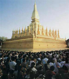
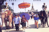
Boun That Luang: is a three-day religious festival celebrated at full moon in November. It begins with pre-dawn gathering of ten thousands of pilgrims from Laos and Thailand at That Luang who listen to prayers and sermons chanted by hundreds of monks representing all Lao vats. During the following days a fair is held nearby. The festival ends with a huge fireworks display.
Vientiane Municipality
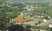
Vientiane is the capital of Laos. It is located on the bank of the Mekong river. Through the largest city in the country. Most travellers are fascinated by the city's exotic Eurasian setting.
The confluence of several cultures has given Vientiane an appealing ambience. Tree-lined boulevards, French historical dwellings and Buddhists temples dominate the scene of central Vientiane and impart a unique character of timelessness.
Vientiane's That Luang stupa is the most impressive and biggest stupa in Laos, featured on the Lao insignia. This stupa was constructed in 1566 by King Setthathirat. The Siamese damaged it badly during their invasion in 1828, but it was restored in the 1936s. In mid-November, religious rites as well as a fair are held here during the That Luang festival.
Vat Phra Keo was also constructed by King Setthathirat. It was rebuilt after the Siamese razed it during the Siamese Lao war of 1828. The building had housed the Emerald Buddha until it was taken to Bangkok following a skirmish with the Lao in 1778. Vat Phra Keo still displays some of the finest Buddha sculptures found in the country.
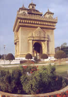
The Patousay on Lane Xang Avenue is a large moument reminiscent of the Arc de Triomphe in Paris Its architecture incorporates typical Lao motifs. From the top one can have a panoramic view of the entire city.
Vat Sisaket is the oldest temple of Vientiane which has survived in its original form. Inside the main hall, and along the walls of the courtyard surrounding it, a total of 6,840 Buddha images rest in small niches or on shelves. At Vat Ong Teu resides the Buddhist Institute where monks can study their religion under the guidance of senior instructors.
Revolutionary Museum, housed in an impressive French colonial building. The museum pays tribute to the sacrifices of the Lao People in freeing the country from colonial rule. The upstairs galleries feature photographs, artefacts and old weapons from the revolution as well as maps, paintings and dioramas. Downstairs holds an archaeological display and exhibits about modern Laos.
Hours: 08.00-11.30, 14.00-16.00, Saturday 08.00- 11.00.
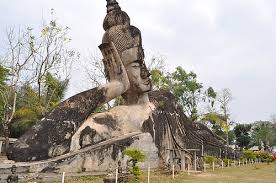
Vat Xieng Khouang (Buddha Park): the park is in pleasant and it's a religious sculpture park located by the Mekong river 24 kilometres downriver from Vientiane. Features include an enomous concrete reclining Buddha, three-tiered model of heaven, earth and which visitors may climb through. Hours: 08.00-16.30.
Vientiane province
 Vientiane province offers impressive scenery. At Vangvieng, 160 km north of Vientiane municipality, limestone formations nestle along the Song river. The rocks are honeycombed with numerous caves, the most famous of which is Tham Jang. Many of these caves can be reached by foot from Vangvieng.
Located 90 km north of Vientiane municipality is the Nam Ngum reservoir, a huge artificial lake created as part of a hydroelectric scheme.
The lake is dotted with hundreds of picturesque islands, which can be explored by cruising around in small boats. It might also be interesting to watch the locals felling underwater teak trees which were submerged when the Nam Ngum lake area was inundated. Near the lake, at Vangsang, primitive Buddha images, dating from the 11th century, are carved into a rock cliff.
Phongsaly
 Is situated in the most Northern tip of Laos, enclosed threes sides by China and Vietnam and cut off to overland travel from Oudomsay to the south. It consists of six districts: Phongsaly, Muangmai, Muangkhua, Sombounxay and Yot Ou.
More than twenty ethnicities make up the province's population of approximately 153,400; among them Iko, Loma, Akha, Pusang, Thai Dam, Thai Deng, Yao, Thai Lu, Khamou, Phai, Solo, Lao Hoy... etc. All retain distinct cultures, languages and religious beliefs, though their most obvious difference is their dress of the women of each tribe. Handicraft skills-notably in weaving, embroidery and making silver jewellery are also well developed.
Phongsaly can be reached by road and river from Oudomsay it is possible to travel by road as far as Muangkhua in Southern Phongsaly then continue from Muangkhua by boat. From Luang Namtha it is possible to travel by road via Muangla (Yunnan province, China). From Luang prabang it is possible through the Nam Ou river straight north into the hearth of Phongsaly. Another way, you can travel by Lao Aviation which provides two flights per week.
Huaphanh
Huaphanh province, a mysterious, beautiful and abundant land, is situated in the North East of Laos, bordered by Xieng Khouang and Luang Prabang to the west and Vietnam to the East.
It was the base of the Lao People's Revolutionary activities and especially the historic interest as the geographical heart of the liberation struggle.
The province has a total population of around 247,300; consisting of many ethnic groups, each with their own life styles, costumes, folk ways in wedding and other ceremonies, festivals, folk dances and songs, differing from each other.
 Huaphanh has six districts: Viengxay, Xamneua, Xamtai, Viengthong, Xiengkho and Huamuang. The principal town is Viengxay the former name know as Nakai, according to the former time this area had many of birds, reptiles, wild animals.
The province is also a famous by limestone mountains and caves; more than one hundred caves are located in this area, such as Tham Than Souphanouvong, in 1964 Mr. Souphanouvong came to set up his residence in this cave.
Tham Than Kaysone, the former name known as Tham Yonesong, in 1964 this cave was established for the residence of Mr. Kaysone Phomvihane. Tham Than Khamtay is the part of Tham Xanglot, it was also the residence of Mr. Khamtay Siphandone; consisting of many compartments, such as meeting room, reception room and research room... etc.
Sayabouri
Is situated in the North West of Laos; sharing borders with Vientiane and Luang Prabang in the East and Thailand in the west.
Sayabouri is the most attractive destinations with sights and charms peculiar to itself and picturesque North-West region.
 The landscape of Sayabouri is magnificent by several peaks altitudes of more than 1000 metres; the meadows and pastures with flower in full boom; the thick and tangled virgin forests etc.... there are many beautiful things to see in Sayabouri.
The principal town is commonly called Muang Sayaboury, where many impressive temples such as Vat ban thin, Vat Ban Phapoun and Vat Ban Natonoy are located.
The area of Muang Phieng, such as Ban Fainamtan, Ban Nakhem and Ban Nampoui have a tradition of agriculture because the land is fertile suitable for agricultural production; particularly rice, water melons, cabbages and sugar cane.
According to the local tradition, people who live in this area have been using elephants for pulling logs.
Luang Prabang
 Luang Prabang is the ancient capital city of the Lane Xang kingdom. According to legend, its first name was Muang Swa.
Later it was now as Xieng Thong. In recognition of the city's vast array of Lao monuments and its historic and culturally significant setting, UNESCO declared Luang Prabang as a World Heritage Site in 1995.
Luang Prabang is situated at the confluence of the Khan and Mekong rivers. It is surrounded by green hills and impresses travellers with its gleaming temple roofs and crumbling French architecture. The town is dominated by the Phou Si hill. On its slopes several vats can be visited, and it is peaked by a 24 metre high stupa, That Chomsi. The top of Phousi affords astonishing views, especially during the serene sunsets which are characteristic of Luang Prabang.
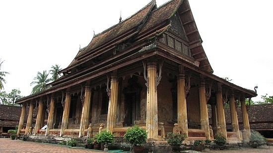
Luang Prabang offers a numerous attractions. Vat Xieng Thong, built in 1560, represents classic local temple architecture. Its sim (chapel) is richly decorated and has a notable roof sweeping low to the ground. Other interesting temples are Vat Wisunalat, Vat Aham and Vat That Luang.
The Royal Palace Museum was constructed 1904-1909 as King Sisavang Vong's palace. These days it functions as a museum. It houses the royal throne and some interesting royal artefacts. The building itself features a mixture of French beaux arts styles and traditional Lao motifs.
The ground floor of the museum is divided into several halls and rooms in which are displayed gifts from other countries to the Lao Kings and collections of swords and Buddha images.
The room to right of the entry hall, once the King's reception room, has walls covered with large-scale murals painted in 1930 by the French artist Alix de Fautereau. They depict scenes from traditional Lao life. A room in the rear of the former palace contains a small collection of traditional musical instruments and dancer's masks used for performances of the great Indian and Southeast Asia epic the Ramayana.
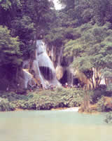
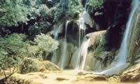
The spectacular Kuang Si waterfall is situated 29 km south of Luang Prabang deep in the forest. The waters tumble over multi-tiered limestone formations into several cool, turquoise green pools ideal for relaxation and swimming.
 Equally fascinating are the Pak Ou caves which can be reached by a 2 hours boat trip upstream from Luang Prabang. They are located within the steep rock-cliff which rises vertically from the waters of the Mekong river at the point where it meets with the Nam Ou river. The lower cave, called Tham Ting, and the upper cave; Tham Prakachay, shelter numerous Buddha images of varying styles, ages and sizes, which have been brought to the cave by generations of Buddhistsd.
Every april, during the celebration of the Lao New Year, Luang Prabang residents come up the Mekong by boat to make merit at the cave. The people bring Buddha images made of wood and metal as offerings.
Bane Pak Ou: on the eastern bank of the Mekong river opposite the caves of Tam Ting is Bane Pak Ou is a fishing village which regularly supplies fish to the market in Luang Prabang.
The village grow rice in the paddy fields behind the village.
The village is a peaceful place with a thriving elementary school small shops sell among other things sweets and bottled drinks.
Xieng khouang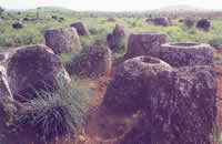
Xieng khouang province offers the awesome beauty of high green mountains and rugged karst formations. The original capital city, Muang Khun, was almost totally obliterated by US bombing and consequently, the capital was moved to nearby Phonsavanh. Of several Muang Khun Buddhist temples built between the 16th and 19th century, only ruins remain.Vat Pia Vat, however, survived the bombing and can be visited.
The main attraction in Xieng khouang province is the Plain of Jars. Stone jars of different sizes, apparently carved out of solid rocks, are scattered all over the plateau. The biggest one reaches a height of 3.25 metres.
Researchers have advanced different theories as to the function of the 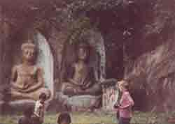 stone jars, which are estimated to be 2,500 to 3,000 years old. According to local legend, in the 6th century King Khun Chuang had the jars constructed in order to store wine for the celebration of his conquest of Xieng khouang. Alternatively, some researchers have suggested the jars were crafted as sarcophagi. This theory is supported by the discovery of human bones and daily utensils nearby. To date, the exact use of the jars remains a mystery.
Approximately 52 km north of Phonsavanh, hot spring will appeal to travellers in search of relaxation. The waters of both, Ban Noi (Little Spring) and Ban Yai ( Big Spring), reach a temperature of around 600C.
Bokeo
 Located along the three-border intersection of Laos, Myanmar and Thailand, form part of the Golden Triangle. It is home to a large number of minorities. Bokeo has five districts : Houixay, Ton Pheung, Muang, Pha Oudom, with 36 townships, more than 450 villages and a total population of 61,000; consisting of many ethnic groups, each with own lifestyles and customs. The most lucrative occupation in Bokeo is gold panning and digging for precious stones, where you can see at Ban Nam Khok (The Lu village), 6 km from the town and Ban Houi Sala (The Hmong village), it's around 18 km far from the town of Houixay.
At Ban Namkeung Kout, Ban Namkeung Mai and Ban Done Deng, its's 26 km far from the centre of Houixay town to the north where you can visit the traditional Lu village, who came originally from Muang Sing, Luang Namtha. The villages can be reached by boat trip, upstream from Houixay.
Oudomsay
 This mountainous northern province is wedged between Luang prabang in the east, Phonsaly in the north east, Sayabouri in the south and china sharing a small northern borders. Most of the provincial population of 283,000 is a mixture of 23 ethnic groups such as Hmong, Iko, Khamu, Lamet etc, each with it own distinct culture, religious, language and colourful style of dress.
They are nonetheless hospitable and welcome visitors to their singular cultures are mostly untouched by 20th century.
The capital, Muang Say, lies between two strings of Hmong villages.
Oudomsay is also the ideal base for excursion and trekking to the varied sights and attractions, as well as destination in its own right.
Near Muang Say a waterfall, Lak Sip Et, attracts visitors, as do the hot springs near Muang La. Muang Say is connected by road to Pakbeng, a rustic town stretching along the Mekong. From there one can continue to Luang Prabang by boat, passing stone cliffs, undulating mountains and little fishing villages.
Luang Namtha
Luang Namtha is a northern province bordering on China and Myanmar and its selection is based upon a series of environment, social, cultural, historical and development factors which make the site an excellent location to evaluate the potential for sustainable cultural and ecotourism in and around a protected area. The forest are dense, and cover near 99% of the protected area. Wild cattle (gauar and banteng), Asian wild dogs, tigers, clouded cleopard, bears and gibbons also having in the forest and there is still a large bird population.
 The area is populated by a variety of different ethnic groups. They consist of Khamu, Akha, Hmong, Yao (Mien). Besides the province also consist the lowland Lao, Tai Lue, Thai neua and Thai Dam who live in village just outside the protected area and the historic town of Muang Sing originally formed par tof group of principalities loosely linked under the leadership of a political entity called the Sipsongpanna whose political seat centered in southern Yunnan province, China.
This province has a picturesque beauty with mountains, and many old temples. Although many temple have been destroyed during the war, there still remains one major attraction, and old temple noticeable different from other classical temples.
Usually tour itinerary includes an outing to Boten, the Lao-Chinese border checkpoint. South west of Luang Namtha, thestill pristine forests of Nam Ha protected area with varieties of wildlife and vegetation can be found
Is located in the central Laos in the narrow "neck" with moderately high mountains sloping south west into the Mekong river valley.
Vientiane and Xieng Khouang provinces lie to the north, Khammouane province to the south. Paksan the capital town is a commercial centre. In Borikhamsay province, between Vientiane and the provincial capital Paksan, a "footprint of Buddha" – shrine at Vat Phra Bat is an important pilgrimage site.
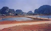
The most famous attraction of the region is its striking landscape. At Ban Nahin, Poupha Mane, a stone forest featuring thousands of rock pinnacles, can be found. Due to its proximity to Lak Xao, the later is within easy reach for tourists crossing to Vietnam. South of Lak Xao, the still pristine forests of Nam Thuen, protected area with varieties of wild life.
Khammouane
Is situated in the central part of Laos PDR with an area of moderately high mountains sloping down to the Mekong valley. Fertile land here is well suited to plantations of rice, cabbage, sugar cane, bananas etc…
A total population of 260,000 is made up of low land and uplanders Lao groups: Phuan, Tahoy, Kri, Katang etc...
Thakhet is the provincial capital and is well-know to day - tripping Thai from Nakhon Phanom, just across the Mekong river. It also has many well- preserved French colonial architecture similar to that found in Vientiane.
About 8 kilometres to the south of the town is the That Sikhotabong or Sikhotabong stupa, constructed around 9th to 10th century by King Nanthasen and restored in the 1950s. Besides, Khammouane province also rich with many caves, such as Tham Xieng Lieup, Tham Nang An, Tham Phanan and Tham Phaya In...
Savannakhet
 Khathabouly, the provincial capital of Savannakhet, is a busy market place for trade with nearby Thailand. Numerous examples of French architecture tell of the town's importance during the colonial area. Khathabouly's is main attractions are its noteworthy temples such as the beautiful Vat Saya Phoum and That Inghang. The later is the holiest edifice in southern Laos, housing a hollow chamber with a distinguished collection of Buddha images.
Near Muang Phin, on the route to Vietnam, dinosaur remains are on display. They were discovered by a French scientist in the 1930s. Not as old as these prehistoric relicts, but of no less significance, is the northernmost example of Khmer art at Heuan Hin (stone house). The building were constructed between 553 AD and 700 AD. Today little more than unrestored ruins remain.
Visitors interested in the latest period of Lao history may want to visit the former Ho Chi Minh Trail, whose outer edges are next to Xepon, 170 km east of Khanthabouly. North and south along the trail, remnants of downed US helicopters, fighter planes and other war material can be seen.
Saravane
Saravane province, a South-eastern province situated on the Bolavens Plateau is devoted to agriculture and nature offering idyllic scenery. A prehistoric site xists not far from the cascades where a wonderful scene can be seen. Within a cave huge stone caskets are piled one on top of the other, providing not only beauty but much interesting thoughts as to how it originated. Tat Lo, Lodge. It's located on the Northern edge of the Bolaven Plateau right beside the Sexet Dam, it's only 10 metres high. The bungalows are blended into the embankment surrounded by lush tropical vegetation. A tour of the area on elephant back is an exotic attraction, or exploring the ethnic minority villages on the Bolaven Plateau can provide a variety if interests.
Sekong
Is situated in the heart of the South-eastern part of Laos; has common borders with Saravane to the West, Champassack and Attapeu to the Suoth and Vietnam to the East.
The province has a total population of around 64,200. Overall, the Sekong river valley is characterized by a Landscape of a fertile plain patterned with a patch- work of rice paddies and fruits orchard. Dotted through out are villages and small towns; such as Lanam, Kaleum, Dakchung and Thateng, where the majority of people follow the unchanging lifestyle of traditional farming.
Its also a complex geographical conditions form colourful Eco-Tourism resources because it's famous by rich of untouchable tropical forest, home to many rare species of flora and fauna.
Attapeu
The most south-eastern tip province of Laos, sharing borders with Sekong in the North, Champassack in the west, Vietnam in the East and Cambodia in the South. The province has a total population of around 87,700; consists of five districts: Saysettha, Samakhixay, Sanamxay and Phouvong. The town is built in a large valley surrounded by mountains and also in the loop of the river, opposite the confluence of the Sekong and Sekhamane rivers. Where the join an island is formed by a small arm of water connecting them upstream.
In early morning you can visit the traditional market, where many different minorities go to buy and sell their product.
Most of the population in Saravane, Sekong, Attapeu are uplanders minotities. Comprising nine major tribes: Alak, Katang, Kaleum, Katou, Suay, Nge, Lave, Tahoy, Nyaheung.
Champassack
Champassack, lies to the South Western Laos, the capital of Champassack is Pakse which located at the confluence of the Mekong and the Sedon rivers. Champassack lush, fertile land encouraged rice cultivation. It's one of the largest producers of rice in the country. Parts of Bolaven Plateau, which rests on the border of Saravane and Champassack are used for cultivation of coffee, cardamon, bananas and other crops.
 Other parts, however, still offer pristine nature, especially in the mountainous central part constituting Dong Hua Sao, a proposed protected area. Several waterfalls drop over the escarpment. One of the most spectacular is Tat Phan with a high of 120 metres.
Forty six kilometres south of Pafse, Vat Phou, one of the most important sights in Laos, is located. Vat phou literally means mountain temple. The different levels of the temple structure, built along the slope of the adjacent mountain, date from the 6th century to the Angkor period of the 9th to 13th century. The upper platform of the temple affords a wonderful view of the Mekong plain. Energetic visitors may want to climb the near by Phou Passak, whose peak is shaped like a lingam or Shiva phallus. Another Khmer monument, Muang Tomo or Oum Moung, can be visited on the opposite side of the Mekong. It is, however, less accessible than Vat Phou.
Phapho Village : located 67 km south of Pakse on the road No.13. The Dong Houa Sao forest reserve is in this area has dense jungle and abundant wild animal life. Elephant can be ride to this forest reserve. The area has the remains of an ancient Khmer stone temple on Mount Phou Asa.
At the south-western tip of Laos, along the Cambodian border, the Mekong river reaches its maximum breadth of 14 km (during the rainy season). When the water level falls back again in the dry season, thousands of small islands rise from the river, giving the area the name Si Phan Done (4000 islands). The biggest island with 55,000 inhabitants is Done Khong, a peaceful place for an overnight visit. From here, South East Asia's biggest waterfalls, Khone Pha Pheng, are within easy reach by boat or by road. Another interesting island in this area is Done Khone, where the French built a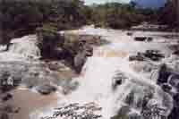 14 km long railway to by pass the rapids. Visitors can follow the old locomotive, pass a massive French - built bridge and watch a series of huge river cascadeds called Tat Somphamit, also known as the Li Phi falls. From the southern tip of Done Khone a small island is accessible from which Irrawaddy dolphins can be watched during the dry season and it is existed only one place in Asia. Mekong Dolphin Conservation Center is located on Done Khone Island. Tourists are welcome to visit the center. To visit the center, visitors must go by road to Bane Veunkham village and then take a boat north a few kilometres to the center.